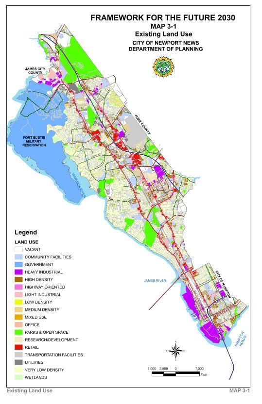
Existing Land Use
Figure 3-2 summarizes existing land use in the City. As of June, 2008, the City, including Ft. Eustis, was more than 90 % developed.

As indicated by Figure 3-2, 31% of the City's land is developed for residential uses, 5.1 % of the land is used for commercial and office uses and 6.1 % of the land for research and development and industrial uses. Transportation facilities, such as the Newport News-Williamsburg International Airport and utilities, utilize 2.7 % of the City's land area and streets and the public right-of-way use 12.6%. Community facilities such as schools, hospitals, museums and churches use 5.2 % of the City's land. Over 10 % of the City's land is in parks, open space, recreation and wetlands. About 19% of the City's land is used by the military or federally owned, with most in Ft.Eustis. Only 9.1 % of the City's land remains vacant and undeveloped.
|
Land Use |
2000 |
2007 |
Δ Acres |
% Δ |
||
|---|---|---|---|---|---|---|
|
Acres |
% |
Acres |
% |
|||
| Parks/Open Space/Wetlands |
4,587 |
10.4% |
4,628 |
10.3% |
41 |
0.9% |
| Residential |
13,554 |
30.6% |
13,738 |
30.5% |
184 |
1.4% |
| Commercial |
1.688 |
3.8% |
1,699 |
3.8% |
11 |
0.7% |
| Office |
488 |
1.1% |
576 |
1.3% |
88 |
18.0% |
| Research and Development |
213 |
0.5% |
231 |
0.5% |
18 |
8.5% |
| Industrial |
2,700 |
6.1% |
2,525 |
5.6% |
-175 |
-6.5% |
| Community Facility |
2,124 |
4.8% |
2,287 |
5.1% |
163 |
7.7% |
| Transportation & Utility |
1,205 |
2.7% |
1,217 |
2.7% |
12 |
1.0% |
| Military/Federal Owned |
8,462 |
19.1% |
8,379 |
18.6% |
-83 |
-1.0% |
| R-O-W/ Road System |
5,454 |
12.3% |
5,663 |
12.6% |
209 |
3.8% |
| Total Developed Acreage |
40,475 |
91.4% |
40,943 |
90.9% |
468 |
1.2% |
| Vacant |
3,813 |
8.6% |
4,100 |
9.1% |
287 |
7.5% |
|
Total Acreage |
44,288 |
100.0% |
45,043 |
100.0% |
755 |
1.7% |
Land Consumption and Redevelopment
The City's population density is 4.5 people per developed acre, which is lower than it was in 1960 (4.8 people per developed acre.) Since the early1990s, the consumption of vacant land has dropped because new development is being built on land previously used or redeveloped. Redevelopment creates sites for residential, commercial, industrial and other uses by converting obsolete uses to new uses. Vacant land from 2000 - 2007 increased by 287 acres and Industrial fell by 175 acres because of the conversion of land to other uses. Residential land uses increased slightly overall by 184 acres because of a land transfer with York County. The City's population growth will be slower as it runs out of vacant land and the area household size drops. Most new growth will occur through redevelopment. For example, closing of the Denbigh Landfill created space for a new Stoney Run Park. The Virginia Advanced Shipbuilding and Carrier Integration Center (VASIC) is built on the site of the former City warehouse. The demolition of substandard housing at Lassiter Courts, Woodsong and Glen Gardens created space for new homes at lower densities.