
Need for a Balanced Transportation System
Congestion factors in Newport News and Hampton Roads include geography, increased maritime activity, truck traffic, higher numbers of registered vehicles on the road, and more miles traveled for work and recreation. Increased traffic is most noticeable on City streets during the morning and evening commute hours, on Saturdays when people are shopping, and during summer months when tourism and beach traffic is highest. Traffic congestion results in lost time, increased energy consumption and air pollution. Between 1990 and 2000, the mean travel time to work increased from 20 minutes to 23 minutes. Most people drive alone to work, although gas prices are rising. The Census Bureau’s 2005 American Community Survey estimates that 83% of workers drove alone.
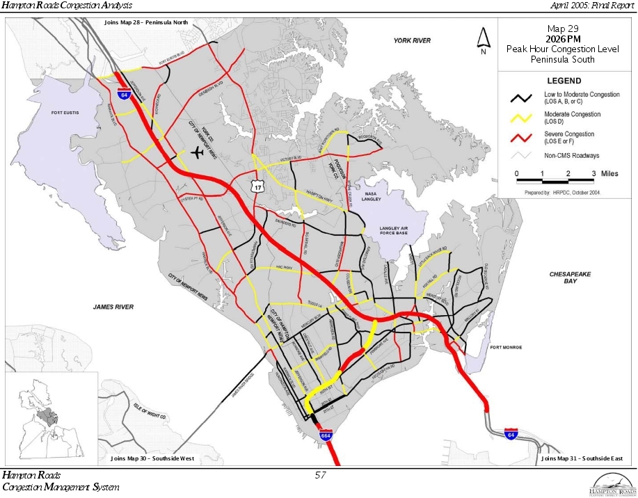
Even with planned street improvements, traffic congestion will deteriorate in the future. Major traffic congestion points in Newport News are I-64, Warwick Boulevard, Denbigh Boulevard, Bland Boulevard, Oyster Point Road, J. Clyde Morris Boulevard and Jefferson Avenue. Sections of these streets will continue to experience Levels of Service (LOS) E and F for motorist delays. (See Table 4-2, Level of Service Definitions and Figure 4-1, 2026 PM Peak Hour Congestion Level Peninsula South.)
More balance is needed in the transportation system to provide alternative forms of transportation and help reduce congestion. Car pooling, van pooling, greater use of public transportation, staggered work hours outside peak traffic periods, telecommuting, enhanced bus service, bicycling, walking and the development of rapid transit, such as light rail and commuter rail, will help reduce congestion on the City's streets. Balancing the transportation system requires more efficient land use patterns, such as mixed use, pedestrian oriented transit developments that encourage walking and greater use of public transit.
Traffic congestion contributes to air pollution in the region. The Environmental Protection Agency (EPA) regulates the amount of ground level ozone in the region. In June 2007, the Hampton Roads Region was re-designated by the EPA to attainment for the eight-hour national ambient air quality standard for ozone. Air quality in the region has improved because of higher standards for automobiles, requirements for low sulfur gasoline and diesel fuel, better on-road and off-road diesel engine standards, and other measures. The region is required to implement an air quality maintenance plan. Therefore, the region’s transportation improvement program and fiscally constrained long range transportation plan must meet air quality conformity rules.
Reduction of traffic congestion, implementation of new technologies, and development of transportation and land use alternatives that reduce reliance on the car will help Hampton Roads continue to improve its air quality. Hopefully the Hampton Roads Region will keep its current standing when the EPA publishes area designations based on the new ozone attainment of 0.075 parts per million (PPM).
|
LOS |
Roadway Segments or Controlled Access Highways |
Intersections |
|---|---|---|
|
A |
Free flow, low traffic density |
No vehicle waits longer than one signal indication. |
|
B |
Delay is not unreasonable, stable traffic flow |
On a rare occasion, motorists wait through more than one signal indication |
|
C |
Stable condition, movements somewhat restricted due to higher volumes, but not objectionable for motorists. |
Intermittently, drivers wait through more than one signal indication and occasionally backups may develop behind left turning vehicles, traffic flow still stable and acceptable. |
|
D |
Movements more restricted queues and delays may occur during short peaks, but lower demands occur often enough to permit clearing, thus preventing excessive backups. |
Delays at intersections may become extensive with some, especially left-turning vehicles waiting two or more signal indications, but enough cycles with lower demand occur to permit periodic clearance, thus preventing excessive backups. |
|
E |
Actual capacity of the roadway involves delay to all motorists due to congestion. |
Very long queues may create lengthy delays, especially for left turning vehicles. |
|
F |
Forced flow with demand volumes greater than capacity resulting in complete congestion. Volumes drop to zero in extreme cases. |
Backups from locations down-stream restrict or prevent movement of vehicles out of approach, creating a storage area during part or all of an hour. |
Street Improvements
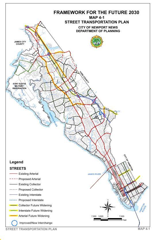
Traffic forecasts indicate that poor levels of service (E and F) are expected on the City’s major roads in 2026 during the peak hour despite planned improvements. Two major arterial streets run the length on the City: Jefferson Avenue and Warwick Boulevard. The CSX corridor separates these two arterial streets, and I-64 runs between them north of City Center. The east-west arterial streets connecting Jefferson Avenue and Warwick Boulevard are Yorktown Road, Ft. Eustis Boulevard, Industrial Park Drive, Denbigh Boulevard, Bland Boulevard, Oyster Point Road, Harpersville Road, J. Clyde Morris Boulevard, Main Street, Center Avenue, Mercury Boulevard, 39th Street and 28th Street.
New Arterial Streets
Atkinson and Middle Ground Boulevards are new connectors planned between Warwick Boulevard and Jefferson Avenue. These two new streets are necessary for traffic to move efficiently in the City, with Middle Ground Boulevard being of highest priority and under consideration for accelerated construction as a Public/Private Transportation Act project.
Independence Boulevard is a planned connector road that will be a four lane divided arterial between Denbigh and Ft. Eustis Boulevard. Independence Boulevard be built and paid for by the developer of the Huntington Pointe development and will include a multi-purpose trail to encourage bicycle and pedestrian use. The road design will require City approval and would be constructed at no cost to Newport News taxpayers. Independence Boulevard will help relieve congestion on Jefferson Avenue and will make no connections to Richneck Road until it connects to Ft. Eustis Boulevard.
Arterial Improvements
Major arterial street improvements being planned include the widening to six lanes of Jefferson Avenue, J. Clyde Morris Boulevard, Oyster Point Road, and Warwick Boulevard. Six through lanes are the widest that these streets can be built without destroying existing parking lots, trees and landscaping on adjoining properties or negatively impacting surrounding land uses. They should not be widened to more than six through lanes.
Route 60 Relocation
Warwick Boulevard(Route 60) will be relocated between the Ft. Eustis Boulevard interchange and the James City County line. A new relocated four lane Route 60 will redirect truck traffic away from the historic Lee Hall community through the Oakland Industrial Park and the Greenmont Industrial Park in James City County at the Grove Interchange. The Route 60 Relocation will be built as a Public/Private Transportation Act project. With the southern Lee Hall Bypass, Route 60 Relocated will reduce through traffic on Yorktown Road.
Interstate 64 Widening
Plans prepared over the last ten years--the 2030 Regional Transportation Plan, the 2026 Regional Transportation Plan and the I-64 Major Investment Study--recommend widening I-64 to eight lanes. The widening will occur between Jefferson Avenue and Route 199 in James City County and include High Occupancy Vehicle lanes. I-64’s construction will be funded with revenues from electronic tolling with variable pricing and other state revenues. The design, engineering and construction of I-64 should avoid widespread tree destruction, and protect the Lee Hall Reservoir during the widening project. Attractively designed bridges, retaining walls, sound walls, guard-rails, tree protection and other features should be required. To obtain higher levels of design, VDOT should engage a landscape architect design team for the I-64 widening.
| Year* | Improvement | Location | 2030** | Cost (EST.) |
|---|---|---|---|---|
|
New Arterial/Collector Roads |
||||
| 2009-2012 | Independence Blvd.*** | Denbigh Blvd. to Ft. Eustis Blvd. | 29,000 | $10 Mil |
| 2016 | Middle Ground Blvd. Extension | Jefferson Ave. to Warwick Blvd. | 38,000 | $44 Mil. |
| 2030 | Atkinson Blvd. Extension | Warwick Blvd. to Jefferson Ave. | 30,000 | $1 Bil. |
| 2030 | Route 60 Relocated | Ft. Eustis Blvd. to N. City Line | 15,000 | $78 Mil. |
|
Arterial/Collector Road Improvements |
||||
| 2007-2010 | Jefferson Ave. Widening | Buchanan Dr. to Green Grove Ln. | 55,000 | $28 Mil. |
| 2008-2010 | Richneck Rd. Widening | Jefferson Ave. to Indep. Blvd. | 15,000 | $6 Mil. |
| 2009-2012 | Denbigh Blvd. Widening | Huntington Pointe to East City Line | 35,000 | $1 Mil. |
| 2010 | Warwick Blvd. Widening | J.C. Morris Blvd. to Nettles Dr. | 57,000 | $100 Mil |
| 2012 | Richneck Rd. Realign. | Huntington Pointe | 15,000 | $2 Mil. |
| 2015 | Ft. Eustis Blvd. Widening | Jefferson Ave. to East City Line | 30,000 | $22 Mil. |
| 2030 | J.C.Morris Blvd. Widening | I-64 to Harpersville Rd. | 62,000 | $42 Mil. |
| 2030 | Jefferson Ave. Widening | Green Grove Ln. to Ft. Eustis Blvd. | 43,000 | $75 Mil. |
| TBD | Oyster Point Rd. Widening | Warwick Blvd. to Jefferson Ave. | 53,000 | N/A |
| TBD | Campbell Rd. Widening |
Bland Blvd. to Warwick Blvd. |
N/A | $6 Mil. |
|
Interstate Projects |
||||
| 2015 | I-64 Widening | Jefferson Ave. to Route 199 East | 106,000 | $500 Mil. |
| TBD | Bland Blvd. Interchange | 1-64/Campbell Rd./Chatham Dr. | N/A | $120 Mil. |
| TBD | Atkinson Blvd. Interchange | I-64 | N/A | N/A |
| TBD | Third Crossing Bridge | I-564/I-664 | N/A | $4 Bil. |
|
Public Transit |
||||
| TBD | Peninsula Rapid Transit | CNU to Huntington Pointe | N/A | $250 Mil. |
| TBD | Intercity Rail | Richmond-Williamsburg-NN | N/A | $380 Mil. |
| TBD | High Speed Rail | Washington-Hampton Roads | N/A | $500 Mil. |
| *Estimated year of completion **Projected average daily traffic. Projects financed by a private developer |
||||
Neighborhood Impacts
Traffic affects safety and livability in residential neighborhoods because of noise, speeding and cut-through traffic. To create a safe and pleasant environment in neighborhoods for residents, pedestrians, bicyclists, and motorists, the City must make capacity improvements to its arterial streets and design residential streets to manage volumes and speed in neighborhoods and reduce cut-through traffic. Cut-through traffic occurs when congestion increases on arterial streets and motorists look for alternative routes through neighborhoods. Building planned arterial street improvements and redesigning neighborhoods streets to reduce volume and speed will reduce cut-through traffic. In the long-run, however, a multi-modal transportation system is necessary to provide real traffic relief.
Although the police can reduce speeding in neighborhoods, it draws manpower away from other police priorities. Most speeding violations are made by neighborhood residents. Traffic calming is an effective way to reduce speeding on residential streets. Traffic calming devices, such as “roundabouts” and “chokers,” help slow down traffic. The Department of Engineering and the Police Department work with citizens and; when requested they will install traffic calming devices in neighborhood streets or apply other methods to control traffic and speeding.
Pedestrian friendly roadway design and on-street parking help slow down traffic. Neo-traditional neighborhoods have narrower residential streets, shorter front yard setbacks, a street grid system and tree plantings between curbs and sidewalks that create pedestrian friendly streets. Hilton Village, Port Warwick and City Center are examples of such neighborhoods.
To reduce traffic noise, the Framework’s citizens' task forces prefer landscaping to sound walls whenever possible. Although sound walls are more effective than landscaping at reducing noise, sound walls are less attractive, more expensive, and ineffective when interrupted by streets and driveway cuts.