
Public Transportation
Hampton Roads Transit (HRT) provides bus service to seven cities in Hampton Roads. In Newport News, HRT operates 15 routes and transports over 329,000 riders per month. Express bus is provided to Northrup Grumman Newport News Shipbuilding, Colonial Williamsburg, and the Gwaltney Foods in Smithfield. The Metro Area Express (MAX) bus provides express regional service between the Peninsula and Southside.
The City and HRT work together to identify improvements to service delivery. One priority that will be addressed over the next several years is the installation of bus shelters. The City will receive Congestion Mitigation and Air Quality (CMAQ) funds in fiscal year 2008 to install bus shelters at key bus stops throughout the city. Bus shelters provide safe locations for passengers and increase the convenience of transit service. They are especially necessary for the elderly and disabled in our region.
Surveys of transit riders show they feel public transportation is inconvenient, takes too long to travel a few miles, and is too infrequent. HRT and the City annually evaluate improvements to bus service, including providing more frequent service, route expansions, and route deviation services. HRT’s Vision for the Future presents the key components of the transit authority’s long range vision. Priorities for HRT through 2025 include: providing fixed guideways for rapid transit, creating a strong local route bus network, expanding regional bus services that provides express and regional service to major employment centers in Hampton Roads, and on-call bus services in low density areas.
Priorities for Newport News include: 1) support for the locally preferred alternative for Peninsula Rapid Transit Project (PRTP); 2) improved express bus service to the Newport News shipyard; and 3) improved local route service. HRT needs a light maintenance facility for buses and transfer center in the northern part of the City. These improvements will require expansion of the existing bus fleet and the replacement of existing buses.
The Vision Plan promotes continuation and expansion of TRAFFIX, the regional transportation demand management (TDM) program for Hampton Roads. TRAFFIX’s activities include: carpool matching, the vanpool program, the guaranteed ride program, commuter check program, and employer outreach.
CSX Transportation Corridor
The CSX corridor is an opportunity for creating a new transportation corridor on the Virginia Peninsula. Developing a commuter rail and light rail along the corridor has challenges, including the avoidance of impacts on the CSX’s freight operation, and the need for removing at-grade crossings to prevent traffic conflicts. Yet, with proper planning, engineering and cooperation, the CSX corridor could become a vital component of a balanced transportation system in Newport News and the region.
The Peninsula Rapid Transit Project
The 1997 CSX Corridor Major Investment Study (MIS) examined future transportation improvements in the CSX Railroad corridor between Williamsburg, Newport News, and Hampton. The goal was to provide rapid transit service to the Peninsula. The MIS recommended a Locally Preferred Alternative (LPA) to pursue enhanced bus service for the Virginia Peninsula in the immediate future while working toward building light rail in the long term.
In 2001, the Metropolitan Planning Organization (MPO) reevaluated the LPA and decided to pursue light rail transit in the CSX corridor. Bus service should complement the light rail system. Subsequently, an alternatives analysis was undertaken, which looked at alternative alignments and modal options. A new LPA was selected. It recommended rapid transit service between downtown Newport News and Williamsburg along the CSX corridor, with connections to downtown Hampton, and to the Norfolk Light Rail System through the planned Third Crossing of Hampton Roads.
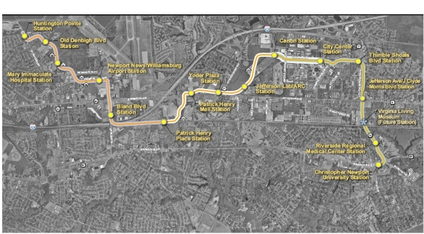
Because of its 32-mile length, cost, and fiscal constraints, the decision was made to identify a minimum operable segment (MOS) as a starter line to implement rapid transit in phases. The City, HRT and its consultant, Parsons Transportation Group, evaluated shorter, alternative alignments for the Peninsula Rapid Transit Project for light rail, bus rapid transit or diesel multiple unit (See Figure 4-2) they were:
- Alternative A1 – Newport News City Hall to Ft. Eustis Boulevard via CSX
- Alternative A2 – Newport News City Hall to Peninsula Town Center (Hampton) via Middle Ground Boulevard Middle
- Alternative A3 – Christopher Newport University to Huntington Point via Jefferson Avenue
In January 2006, the A2 alignment in coordination with Hampton was set aside. In September 2006, the A3 alignment in an independent right-of-way between CNU and Mary Immaculate Hospital was selected as the recommended starter line for evaluation in a draft Environmental Impact Statement (DEIS). The A3 alignment had a substantially lower capital cost and slightly less annual operating cost for light rail and bus rapid transit.
The A3 alternative does not require permission from the CSX to use its right-of-way. It minimizes the need for new right-of-way, and will serve existing and future developments having high travel demand along its route, such as City Center and Patrick Henry Mall. The A3 alternative will be routed through Oyster Point City Center, SCOT, the William and Mary Endowment property and Patrick Henry Place to provide public transit options for new development. The A3 alternative will be supported by premium bus service between Denbigh and downtown Newport News to serve the Shipyard. The three technologies will be evaluated. They are bus rapid transit, light rail, and streetcar.
High-Speed Rail/Commuter Rail
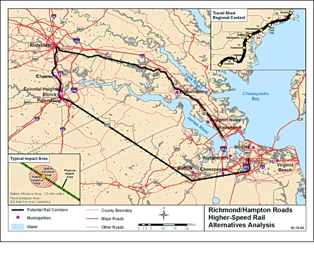
The Southeast High Speed Rail Corridor was identified as the most economically viable high-speed rail corridor in the country by the U.S. Department of Transportation in 1997. The corridor runs from Washington, DC through Richmond to Charlotte, NC. The Richmond to Hampton Roads Corridor was designated as an extension to the main corridor to improve access to Hampton Roads and connect the region to the Southeast, Northeast and Mid-Atlantic regions. The Virginia Department of Rail and Public Transportation (VDRPT) has studied alternative alignments for future high-speed rail service between Richmond and Hampton Roads. Alternative 2B would bring higher speed rail service operating at speeds over 79 mph in the CSX Corridor to Newport News.
Amtrak now provides two daily round trips between Newport News and Richmond at speeds below 79 mph. The Peninsula/CSX Alternative 2B increases the number of round trips to 9 daily and relocate the Amtrak station downtown.
Alternative 2B will advance commuter rail service between Richmond, Williamsburg and Newport News. A future connection to Norfolk will be possible when the Third Crossing of Hampton Roads is built. Commuter rail on the CSX Corridor will connect with light rail stations at Bland Boulevard and J. Clyde Morris Boulevard. The City owns 31 acres at Bland Boulevard that can provide a multi-modal transit center and connection to the Airport.
Other Modes of Transportation
Newport News-Williamsburg International Airport
In 2005, the Newport News/Williamsburg International Airport (NNWIA) handled over one million passengers, an increase of 15.6% from 2004. It was the airport’s fourth straight year of double-digit growth, resulting in a 150% increase from 2001. The increase in local air travel is a result of numerous factors, with the most notable being the increase in low-fare airline services to Florida, Atlanta, New York and Boston.
To accommodate growth, the airport has completed several projects, building new hangars, public parking lots, a multi-level parking garage and an air traffic control tower. To accommodate future growth, the airport is moving forward with other projects such as new general aviation terminal hangars. The Peninsula Airport Commission plans extending its two existing runways, and constructing a new 6,400 foot long parallel runway. These improvements are identified in the NNWIA Master Plan to meet forecasted aviation activity.
If the airport develops a hub relationship with an airline, airport activity could exceed 3 million passengers a year. Cultivating and implementing upgraded air service will enhance the region as a business and tourist destination. Having Newport News/ Williamsburg International Airport become an international port of entry will further enhance the city’s economic vitality. Therefore, it is important to protect the airport’s airspace and ability to expand in the future.
The airport is concerned about tall structures, over 200 feet above ground level, which could occur in its airspace. These tall structures become hazardous obstructions that prevent the airport from developing safely. The City regulates the height of structures and the uses surrounding the airport through zones and overlay districts in its Zoning Ordinance. The regulations are based on Part 77 requirements of the Federal Aviation Administration. The City and Airport recognize the need to modify the City’s zoning ordinance to ensure that airspace is protected around both Newport News-Williamsburg International Airport and Langley Air Force Base. Therefore, the zoning ordinance needs to be updated.
Another concern is the impact of aircraft noise on residences, churches, libraries, hospitals and other community facilities and land uses that are sensitive to loud noise. Inside the 65 db LDN noise contour defined by the Airport’s aviation consultant and the recent Langley AFB AICUZ study, noise sensitive land uses should be required by the City’s building code to have noise reduction installed with new construction, or to have the uses prohibited.
Newport News Marine Terminal
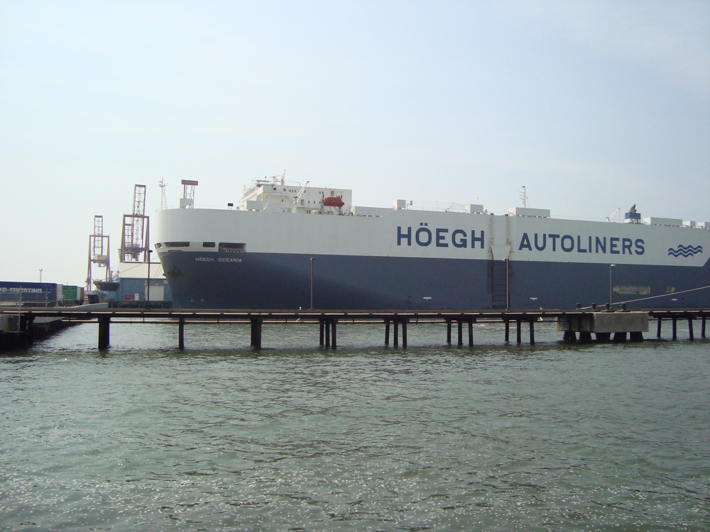
The Newport News Marine Terminal (NNMT) is owned by the Virginia Port Authority and operated by Virginia International Terminals
Inc. The Port of Hampton Roads, with terminals in Norfolk, Portsmouth and Newport News, handles 2 million containers per year.
The Port contributes to the local, regional, U.S., and global economy and its success is tied to its ability to accommodate
domestic and international trade. The NNMT is reaching its physical capacity. The future viability will be dependent upon
the planned expansion of Craney Island in Portsmouth to accommodate increased foreign imports. In 2007, APM Terminals International
opened the A.P. Moller Mersk Terminal in Portsmouth. With a 1 Million container capacity, it is the largest privately owned
terminal in North America. The Mersk Terminal and the planned expansion of Craney Island will increase the number of freight
containers handled by the Port of Hampton Roads to ten million containers annually. Increased truck traffic will require the
completion of the Third Crossing of Hampton Roads and the widening of US Route 460 between Hampton Roads and Petersburg to
Interstate 95.
Ground Transportation
Ground transportation from the Peninsula to other parts of Virginia and the nation is provided by Greyhound Bus terminals in downtown Hampton, Williamsburg and Newport News near the Denbigh-Warwick Shopping Center. Passenger rail currently operates along the CSX corridor at the Amtrak station near Mercury Boulevard across from Huntington Park. Amtrak will be expanding service to Washington, DC. Passenger rail should be encouraged and supported by providing improved intermodal transfers. The existing Amtrak station should be relocated to downtown Newport News, and another station built on Bland Boulevard to provide greater visibility and convenience to the public.
Ferry Service
HRT’s Vision for the Future proposes a new ferry route from downtown Newport News to Norfolk. The route would take passengers from downtown Newport News to downtown Norfolk via the Naval Station. The estimated travel time from Newport News to Naval Station Norfolk is 16 minutes, and the travel time from Newport News to downtown Norfolk is 60 minutes. Two vessels would be required to provide all-day service at hourly intervals. A pier with adjacent bus service would be required to support the ferry in Newport News.