Soils
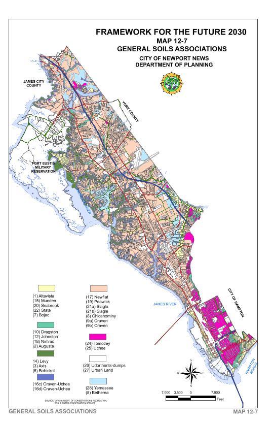
The major soil associations found in the City of Newport News are Chickahominy-Slagle-Craven-Newflat, Tomotley-Augusta-Johnston, Axis-Bohicket-Levy, and Urban-Fill. The Chickahominy-Slagle-Craven-Newflat association is moderately well drained fine loamy and clay like soils, and poorly drained clay soils on gently sloping uplands. Tomotley-Augusta-Johnston association is poorly, somewhat poorly and moderately well drained soils on low terraces with generally thin solums. The Axis-Bohicket-Levy association is salt-water marshes. Urban Fill is generally more than ninety-five percent fill or concrete. Map 12-7 shows the general soil associations within the city.
Only one soil type, Seabrook, has rapid permeability. It is located near Lee Hall Reservoir. Because its location is in Newport News Park it is protected from intense development. Three soil types, Craven-Uchee complex, Craven Fine Sandy Loam, and Slagle Fine Sandy Loam, are highly erodible soils in Newport News. The Craven-Uchee complex is commonly found on slopes six (6) percent to twenty-five (25) percent adjacent to water bodies. Craven Fine Sandy Loam and Slagle Fine Sandy Loam are found on slopes of two (2) percent to six (6) percent. It is important to keep a vegetative cover on highly erodible soils and steep slopes during the land development process so that erosion is minimized and adjacent water bodies are protected from sedimentation during heavy rains.
Because over ninety percent of the City is developed, soil characteristics have limited applicability to the future development patterns in the City. With this caveat, soil characteristics, which may facilitate water pollution, are: depth to the water table, permeability and erodibility. Much of the City has an apparent seasonal high water table depth within 36 inches of the surface. Because of the high-water table new Underground Storage Tanks (USTs), such as for heating oil and gasoline, must be installed according to federal standards and maintained in proper order. Existing USTs should be evaluated for possible leaks. Structures with existing septic tanks should be connected to the sanitary sewer system as soon as a sewer line is within 250 feet regardless of whether or not the septic system has failed.
More detailed information on soils is contained in a technical support document developed to meet the requirements of the State’s Chesapeake Bay Preservation Act.
Soil and Water Contamination
“The Hydrologic Cycle is the cyclical movement of water within the environment. Clouds release moisture through both rain and snow. The moisture that reaches the ground (much is evaporated) wets the soil that starts the process of infiltration or penetration of the water to deeper subsurface zones. When precipitation exceeds infiltration runoff results. Both runoff and precipitation supplies some of the water to surface water bodies." "Water that percolates to subsurface layers of soil and rock is called groundwater. Groundwater supplies approximately 30 percent of the annual flow to surface water bodies in Virginia, from which clouds secure their moisture through evaporation.” (35)
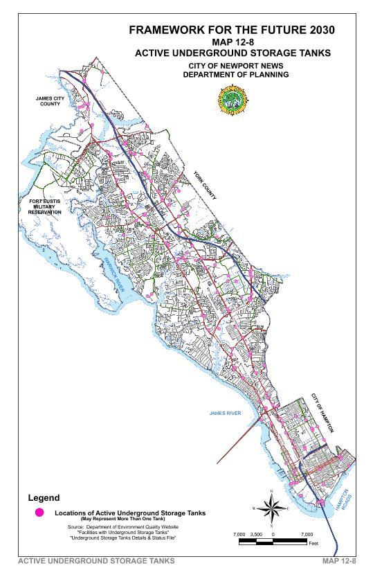
Soil and water contamination occurs when hazardous substances are spilled or leak into the surrounding soil, groundwater, or surface water. One way for this to happen is through leaking USTs. Gas station USTs have the potential to leak petroleum constituents such as benzene, ethyl benzene, polynuclear hydrocarbons, methyl tertiary-butyl ether (MTBE), and other carcinogens into the soils, groundwater, and various other offsite locations. Leaking USTs threaten human health and the environment. Map 12-8 shows the general location of federally regulated USTs in Newport News.
The UST’s for home heating oil are not federally regulated. The City has no program in place at this time for either establishing the number that are leaking and/or encouraging their replacement. More detailed information on underground storage tanks is contained in a supplemental technical support document developed to meet the requirements of the State’s Chesapeake Bay Preservation Act.
The City has used Brownfield Grants for Phase I environmental site assessments on several properties south of Mercury Boulevard. Phase I environmental site assessments identify potential soil and water contamination sources. Map 12-11 identifies these properties or areas.
There are no properties within the jurisdiction of Newport News that are on the Superfund list. However, Fort Eustis has several areas that qualify for the Superfund list.