Water Quality
Water quality is affected by sediments, nutrients, and toxic substances. Sediments are the product of soil erosion that is conveyed through storm water runoff into surface waters. In suspension, sediments block and absorb sunlight causing a rise in water temperatures that threatens the habitat of marine life. Nutrients in the water can create an alga bloom, which causes oxygen depletion in the water as well as causing the water to become murky, thus blocking sunlight. Toxic substances, such as chemicals and heavy metals, can severely damage developing life forms.
James River
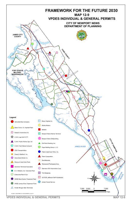
The Department of Environmental Quality (DEQ) administers State Water Control Board regulations, including the Virginia Pollutant Discharge Elimination System (VPDES) permit program. Under the VPDES permit program, domestic wastewater discharges from point sources are under joint supervision of the DEQ and the State Department of Health. The point source VPDES permit facilities are shown on Map 12-9.
The DEQ aggregates and reports data by water body regions. Newport News is part of three water body regions G11, G-15 and C07. The DEQ also assesses Water Body Regions for six designated uses: (1)wildlife, (2) aquatic life, (3) fish consumption, (4) swimming, (4) shellfish harvesting and, (5) Drinking Water. Since 2000, the State Water Control Board has adopted water quality standards for dissolved oxygen and submerged aquatic vegetation. These standards were assessed in the September 2006 report, which identified impaired waters. A copy of the Virginia Water Quality Assessment 305(b) and 303 (d) Integrated Report to EPA and Congress dated 2008 can be found on the Virginia Department of Environmental Quality website at, http://www.deq.virginia.gov/wqa/305b2008.html
| Location | Chlorophyll-A | PCB in Fish Tissue | Dissolved Oxygen | Copper |
|---|---|---|---|---|
| James River (G11) | AL
TMDL 2010 |
FC
TMDL 2018 |
AL&OWAL
TMDL 2010 |
|
| Warwick River (G11) | AL&OWAL
TMDL 2010 |
|||
| Skiffe's Creek (G11) | AL&OWAL
TMDL 2010 |
|||
| Morrison's Creek (G11) Ft. Eustis | AL&OWAL
TMDL 2010 |
|||
| Huntington Beach (G11) | AL
TMDL 2010 |
FC
TMDL 2018 |
AL&OWAL
TMDL 2010 |
|
| Anderson Park Beach (G15) | AL
TMDL 2010 |
FC
TMDL 2018 |
||
| Hilton Beach (G11) | AL
TMDL 2010 |
FC
TMDL 2018 |
AL&OWAL
TMDL 2010 |
|
| King/Lincoln Park Beach (G15) | AL
TMDL 2010 |
FC
TMDL 2018 |
||
| Deep Creek-Lower (G11) | AL&OWAL
TMDL 2010 |
|||
| Lee Hall Reservoir (G11) | AL&OWAL
TMDL 2018 |
AL &WL
TMDL 2016 |
Table 12-3 lists impaired waters for the City of Newport News that will result in studies and implementation plans for Total Maximum Daily Loads (TMDL). It also indicates the use for which it is impaired: wildlife (WL), aquatic life (AL), fish consumption (FC), open-water aquatic life (OWAL), submerged aquatic vegetation (SAV) and recreation.
Chesapeake Bay Nutrient and Sediment Reduction Tributary Strategy for the James River, Lynnhaven and Poquoson Coastal Basins
In 1996, the Virginia General Assembly passed legislation that called for development of strategies to restore water quality and living resources of the Chesapeake Bay and its tributaries.
The March 2005 strategy identifies nutrient and sediment allocations and reduction goals. Point sources received nitrogen and phosphorus permit allocations after new water quality standards were adopted in 2006. Non-point sources will not receive allocations unless determined through TMDL's. The complete document titled James River Tributary Strategy can be found on the Secretary of Natural Resources website at http://www.naturalresources.virginia.gov/Initiatives/WaterQuality/ .
Storm Water Quality
The Department of Environmental Quality formerly administered a VPDES permitting program for storm water discharge that enforced water quality standards for non-point source pollutants in storm water runoff. The Department of Conservation and Recreation (DCR) Stormwater Permitting Division now issues these permits.
The Department of Engineering’s Storm Water Management Division administers the City’s storm water management program and the City’s VPDES permit. The City's Municipal Separate Storm Sewer System discharge permit was reissued in April 2001. The City has submitted a reapplication of the Municipal Separate Storm Sewer System (MS4) Program Plan to DCR. The City's MS4 discharge permit was approved by the Board of Soil and Water Conservation in November of 2007. The City's MS4 permit is at EPA for final approval.
The City’s MS4 discharge permit requires :
- Inspecting and maintaining existing public and private structural and nonstructural Best Management Practices (BMP), i.e., wet ponds, dry ponds, infiltration trenches, and vegetation, etc.;
- Planning policies to be consistent with the permit regarding new development and redevelopment, which includes Environmentally Sensitive Design and Low Impact Development;
- Maintenance activities of public streets, roads and highways to minimize discharge of pollutants;
- Inspecting municipal facilities for potential pollution sources and taking corrective actions as necessary;
- Reducing pollutant discharge from pesticides, herbicides and fertilizer on public property;
- Prohibiting illicit discharges and improper disposal of used motor vehicle fluids, hazardous household waste, grass clippings, leaf litter and animal wastes, etc.;
- Implementing a spill prevention and response program;
- Identifying and controlling pollutants from industrial and high risk runoff; reducing discharge from construction sites; and
- Maintaining and updating the storm sewer infrastructure; and public education and outreach.
Erosion and Sedimentation Control
Erosion and Sedimentation Control regulations were developed to eliminate or reduce the amount of soil erosion occurring during development when land is cleared of vegetation. Any activity that disturbs more than 2,500 square feet of land requires a Land Disturbance Permit and Erosion & Sediment Control Plan approval. Storm water Inspectors field check approved construction projects for compliance with state and local erosion and sediment control laws. Erosion and sediment controls protect area waterways, reduce maintenance costs, and prevent damage to the environment caused by siltation.
Shoreline Erosion and its Control
The down slopes of riverbank bluffs on the shoreline are subject to weathering by waves and wind which is accelerated when high water results during severe storms. There are three shoreline areas identified by Virginia Institute of Marine Science (VIMS) as critically eroding. One area is Anderson Park along Hampton Roads or Hampton Flats where the shoreline was eroding at an average of two feet per year, threatening paved walkways and open space. The second area was the Huntington area where bluffs and a beach were eroding. The third area was the Blunt Point-Fishers Creek-Deep Creek area where property did not have existing erosion control structures.
A shoreline management plan was developed for the Newport News Hampton Roads shoreline by VIMS. This plan is specific to Anderson Park area but also addresses the entire shoreline west to King Lincoln Park. To prevent erosion at Huntington Park, riprap was installed at the toe of the bluffs and along the boat ramp on the north side of the bridge. The beach was reconfigured and nourished to create a “new” beach. Along River Road, south of the James River Bridge, riprap was placed at the toe of the bluff to prevent erosion.
In the Deep Creek-Fishers Creek-Blount Point area the shoreline is privately owned. Therefore, shoreline erosion is addressed on a case-by-case basis as property owners install their own erosion control structures.
The most common shoreline erosion control methods used in Newport News are either vertical bulkheads or riprap. "Areas of highly unstable shorelines and/or areas having high levels of reflected wave energy will normally require construction materials which absorb and dissipate wave energy such as riprap or vertical bulkheading with protective riprap at the toe.” (36) For shorelines experiencing mild to moderate erosion, the planting of marsh grass is a preferred means of stabilization. However, this type of stabilization is not appropriate on all shorelines and requires technical expertise. Free advice is available from the Virginia Shoreline Advisory Service and the Virginia Institute of Marine Science.” (37)
More detailed information on shoreline erosion control is contained in a technical support document developed to meet the requirements of the State’s Chesapeake Bay Preservation Act.