Chesapeake Bay Preservation Program
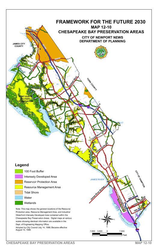
In 1988 the Virginia General Assembly passed the Chesapeake Bay Preservation Act. The law regulates development on lands important for the protection of water quality in the Chesapeake Bay and its tributaries. Those lands are called Chesapeake Bay Preservation Areas, which includes the Resource Protection Areas, Resource Management Areas and Intensely Developed Industrial Waterfront Areas. These areas have differing degrees of development compliance regulations.
Resource Protection Areas in Newport News include: tidal shores, tributary streams, tidal wetlands, non-tidal wetlands, other lands, and the 100-foot buffer area. The non-tidal wetlands in the Resource Protection Areas are connected by surface flow and are contiguous to tidal wetlands or tributary streams. The buffer area is 100 feet wide and has restrictions on uses and activities permitted within it.
Resource Management Areas in Newport News are: Flood plains, Highly Erodible Soils, and All lands within one hundred (100) feet landward of the landward boundary of the RPA buffer. Resource Management Areas are contiguous to the entire inland boundary of the resource protection area and include sufficient area to result in water quality benefits.
An Intensely Developed Area is an overlay of the underlying Resource Protection Area. It removes the development restrictions of the Resource Protection Area. It can be applied where little of the natural environment remains in the Resource Protection Area on land developed prior to October 1, 1989. Land areas must also meet one of the following:
- fifty percent impervious area,
- existing public sewer, water and storm sewer lines, and
- housing density of more than four units an acre.
The City has one Industrial Waterfront Intensely Developed Area. The City plans to investigate the expansion of the Intensely Developed Areas to commercial and residential areas.
The City adopted a Chesapeake Bay Preservation Map and Ordinance in 1990. Since then revisions have been made to the Chesapeake Bay Preservation Ordinance (CBPO) and Map to obtain consistency with the state regulations. Map 12-10 is the adopted Chesapeake Bay Preservation Area Map.
In addition to the Chesapeake Bay Preservation Areas, the CBPA map identifies the Storm Water Management Area. The Storm Water Management Area has the same development requirements as the Resource Management Area.