
4. Balanced Transportation
The City's transportation system provides for the movement of people and goods and is a major factor shaping the City. The type and capacity of the transportation system often determines the land use pattern. For example, light rail transit may attract concentrated land use development around its stations. Conversely, automobile dominant transportation systems encourage sprawling development patterns.
Once a low density, sprawling development pattern is established, it is hard to serve with anything other than the private auto. This is because higher density land use patterns, between 11 to 15 units per acre, are needed to economically support rail and bus transit. A low-density, use separated development pattern impacts the transportation system because it forces people to drive their cars. However, mixed-use development opens pedestrian interaction between uses and is easier to serve with public transit. A balanced transportation system for Newport News is recommended, involving not only streets and highways, but also public transit, bus service, light rail transit, sidewalks and bikeways. This integrated, multi-modal transportation system enables land use and transportation to work together to reduce traffic congestion, improve air quality and achieve a more livable City.
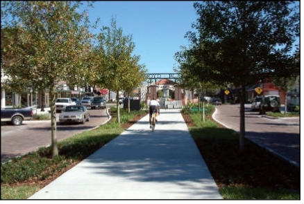
Pedestrian/Bikeway Network
A City-wide network of sidewalks, bikeways and trails is part of the Framework for the Future (See Bikeways Map 4-3). The objective is to provide for safe, pleasant travel throughout neighborhoods and the entire City without the total reliance on the auto. Walking and bicycling provide opportunities for social contact among neighbors, reduces air, water and noise pollution, reduces energy consumption and supports more efficient land use patterns. Pedestrian access plans, for bikeways and sidewalks should be prepared for new developments.
Public Transit
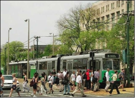
Frequent bus service should be provided on major routes. Also, demand responsive bus service should be developed with smaller, flexible buses going into neighborhoods to pick up or drop off their riders instead of bus service being limited to the major arterials streets. A key feature of the City's future transportation system is rapid transit in the CSX rail corridor, serving Newport News, Hampton, James City County and Williamsburg. Eventually, Rapid Transit is planned to connect the Peninsula with Southside Hampton Roads through the proposed Third Crossing of Hampton Roads. Bus routes will be reconfigured to bring passengers to Light Rail Transit stations. Park and ride facilities will be provided at some Light Rail station sites. Other Rapid Transit stations may have only a platform with very little parking, as in Lee Hall and Hilton Village, to minimize traffic impact on surrounding neighborhoods.
A seven mile starter line is planned on the A3 Alignment between Christopher Newport University and Huntington Pointe. Other stops are planned at Riverside Regional Medical Center, Virginia Living Museum, City Center, the Applied Research Center, Patrick Henry Mall, Patrick Henry Place, Bland Boulevard, Wolseley North America, Newport News Williamsburg Airport and Mary Immaculate Hospital.
Mixed use, high density Transit Oriented Developments are planned within walking distance of several Rapid Transit Stations shown on the Framework for the Future. However, not all station sites will be suitable or appropriate for Transit Oriented Development. High speed commuter rail service is planned to connect the City with Richmond and Washington, with stations in downtown Newport News and at Bland boulevard near the airport.
Transportation centers are planned where passengers can change trains between high speed commuter rail and Rapid Transit. Station area plans should be prepared for each LRT station site and vicinity.
Street System
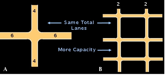
The street system should be designed to support the planned land use pattern while increasing transportation efficiency.
In District I, the traditional street grid pattern should be preserved. In the suburban areas of the City, the number of street
connections between neighborhoods should be minimized to emphasize the distinctiveness of neighborhoods. Adequate neighborhood
connections will remain to permit interaction between adjacent neighborhoods while minimizing through traffic. Modifications
to street patterns will be considered carefully in the context of each individual neighborhood during the formulation of a
complete neighborhood plan.
Ports
The City's windows to the world are its airport and seaport. These provide the impetus for two of the City's major activity centers while providing important transportation connections to the rest of the United States and other countries.
Newport News-Williamsburg International Airport is a valuable transportation link between our region and the world. The Patrick Henry CommerCenter is planned with land reserved for the airport's expansion and a third parallel runway.