
14 THE LAND USE PLAN
Introduction
Christopher Newport, Admiral of the Virginia Company of London, led an expedition to the New World in 1606. He and his company of adventurers arrived in the Chesapeake Bay on April 26, 1607. They had been bound from England by way of the West Indies since December 20, 1606. As they rounded the confluence of Hampton Roads and the James River, they called the location "Point Hope" because it put them in good hope of finding a suitable landing place. Jamestown was founded up the James River a few weeks later. Point Hope was ordered to be a look out point on which a few colonists settled. It was first identified in 1619 as “Newporte's Newes” because of the news from the mother country Christopher Newport would deliver on each return voyage.
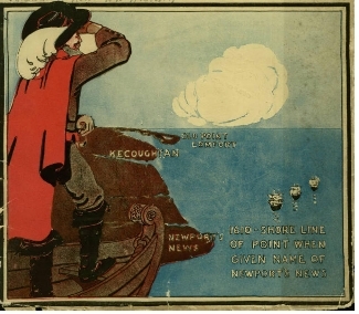
Planning District I is bounded by Mercury Boulevard and Huntington Park to the north, the James River to the west, the City line to the east and Hampton Roads to the south. Planning District I is the oldest developed area of the City. It is an urban area, with different land uses existing within close proximity.
Population and Housing
The January 1, 2007 estimate of the population of Planning District I was 33,346, which is 18 percent of the City's population. Planning District I's population has declined by 4 percent since 2000, while the City's population grew by 4 percent.
The number of housing units in the District is 15,117, a decline of 2 percent since 2000. The major factor contributing to this decline is the demolition of substandard houses and apartment projects. Most housing units are over 50 years in age.
|
Housing Units 12/31/07 |
||||
|---|---|---|---|---|
|
Planning District |
Single Family |
Multi-Family |
Mobile Homes |
Total |
| I |
8,076 |
6,653 |
388 |
15,117 |
| II |
16,640 |
13,712 |
847 |
31,199 |
| III |
12,970 |
8,288 |
873 |
22,131 |
| IV |
4,904 |
5,061 |
265 |
10,230 |
| Total |
42,590 |
33,714 |
2,373 |
78,677 |
Land Use
The predominant existing land use in Planning District I is residential, which is 32 percent of the total area. Industrial use is the second largest existing land use which makes up 23 percent of the total acreage. The existing land use composition of Planning District I is tabulated on Table 14-5.
|
Land Use Comparison Planning District I (2000-2007) |
||||||
|---|---|---|---|---|---|---|
|
Land Use |
2000 |
2007 |
Change (2000-2007) |
|||
|
Acres |
% Total |
Acres |
% Total |
Acres |
% Δ |
|
| Park/Open Space/Wetlands |
149 |
2.8% |
157 |
2.9% |
8 |
5.6% |
| Residential |
1,704 |
31.7% |
1,714 |
31.9% |
10 |
0.6% |
| Commercial |
232 |
4.3% |
238 |
4.4% |
6 |
2.6% |
| Office |
93 |
1.7% |
88 |
1.6% |
-5 |
-5.4% |
| Industrial |
1,240 |
23.1% |
1,212 |
22.6% |
-28 |
-2.3% |
| Community Facility |
328 |
6.1% |
336 |
6.3% |
8 |
2.4% |
| Transportation/Utility |
60 |
1.1% |
59 |
1.1% |
-1 |
-2.2% |
| Military/Federal Owned |
5 |
0.1% |
5 |
0.1% |
0 |
0.0% |
| R-O-W/Road System |
1,296 |
24.1% |
1,296 |
24.1% |
0 |
0.0% |
| Total Developed Acreage |
5,107 |
95.1% |
5,105 |
95.1% |
-2 |
0.0% |
| Vacant |
262 |
4.9% |
264 |
4.9% |
2 |
0.8% |
| Total Acreage |
5,369 |
100.0% |
5,369 |
100.0% |
0 |
0.0% |
The land area of the district is 5,369 acres. The District is over 95 percent developed. Only 262 acres, less than 5 percent, are vacant. Most vacant land is in small lots which are difficult to consolidate for development.
The District I Land Use Plan and the City-wide Land Use Plan illustrate the future land use proposed for Planning District I. Table14-2 compares land use within the District between 2000 and 2007. Citizens have stated that additional recreational space, parks, diverse housing, schools, businesses and jobs were needed in the District.
History of Growth and Development
The City of Newport News was incorporated in 1896 following the construction of the Chesapeake and Ohio Railroad in 1881 and
the Newport News Shipbuilding and Drydock Co. in 1886 by Collis P. Huntington.
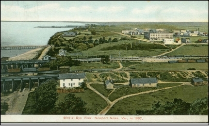
Collis P. Huntington's Old Dominion Land Company created a town to provide housing for the growing work force of the railroad, port and shipyard. It laid out a grid system of streets on both sides of the railroad and developed the residential areas of Newport News that now make up most of Planning District I.
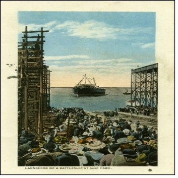
Many of the City's historic buildings are located in the Planning District. The Hotel Warwick, located on West Avenue and 25th Street, was constructed in 1883 and the City's first suburb, North End/ Huntington Heights, was laid out from 1900 to 1935.
Since the merger of the City of Newport News and the City of Warwick in 1958, growth has occurred in the northern part of the City, while Planning District I declined. Many historical structures in the Downtown area were abandoned and demolished.
Issues
Current issues of Planning District I include:
- Stabilization and revitalization of identifiable neighborhoods with a sense of community served by schools, parks, churches and other facilities and amenities.
- Development and redevelopment of community assets including commercial, cultural, open space and parks, human services, employment and business opportunities.
- Creation of new parks and open space, development and redevelopment of existing parks, and the provision of adequate recreational sites to serve the diverse age groups and interests of the district's population.
- Development, redevelopment and improvement of the Downtown and deteriorating commercial areas.
- Preservation and restoration of existing schools and the construction of new schools.
- Preservation of historic structures.
- Implementation of the LDR Maritime Center Plan for Downtown Newport News.
- Implementation of the Southeast Community Urban Waterfront Design Study.
- Increased public safety and code enforcement.